
Digital agriculture is the use of remote sensing technology, geographic information system, global positioning system, computer technology and other information technology to monitor field crop production and livestock production, thereby improving crop and livestock production and quality, and improving the stability and controllability of agriculture. A brand-new agricultural model that maximizes the protection of the ecological environment and ensures the sustainable development of agriculture. Digital agriculture reflects the general trend of agricultural modernization. This article discusses the meaning and characteristics of digital agriculture, the technical system and development ideas of digital agriculture, which leads to the prospect of digital agriculture.

In 1997, the United States formally put forward the concept of “digital agriculture”, which refers to intensive and informatized agricultural technology supported by geospatial and information technology. In 1998, U.S. Vice President Al Gore delivered a speech entitled “The Digital Earth 21st Century How Mankind Knows the Earth”, again defining digital agriculture as “agricultural production and management technology produced by the combination of digital earth and intelligent agricultural machinery technology”. Digital agriculture is quickly becoming the 21st century agricultural development strategy for all countries in the world, striving to seize one of the commanding heights of technology, industry and economy. Currently, 20%’ of arable land and 80% of large farms in the United States have implemented this model, and digital agriculture will be popularized by 2010. Our country’s understanding of digital agriculture is still in the enlightenment stage, but the government has attached great importance to it. my country has established experimental bases in Xinjiang and Beijing to control the operation of agricultural machinery with GPS and remote sensing. Although there is still a lot of basic work to be done in realizing the digital agriculture model, which requires a lot of investment, it should not be too long to enter the substantive stage. Digital agriculture reflects the general trend of agricultural modernization, and it will surely become a brand-new model of agriculture in the 21st century.
1. The meaning and characteristics of digital agriculture
Digital agriculture is also called precision agriculture or information agriculture. Its basic connotation is to combine high and new technology such as remote sensing technology, geographic information system, global positioning system, computer technology, communication and network technology, automation technology and geography, agriculture, ecology, plant physiology, etc. Organically combine basic disciplines such as soil science and soil science to realize real-time monitoring of crops and soil from macro to micro in the process of agricultural production, so as to achieve regular information acquisition of crop growth, development status, diseases and insect pests, water and fertilizer status and the corresponding environment , To generate a dynamic spatial information system; simulate the phenomenon and process in agricultural production to achieve the purpose of rational use of agricultural resources, reducing production costs, improving the ecological environment, increasing the yield and quality of crop products, and ensuring the sustainable development of agriculture.
Digital agriculture is based on field farming, and the whole process from farmland, sowing, irrigation, fertilization, field management, field management, plant protection, yield forecasting to harvesting, preservation, and management is realized digitization, networking and intelligence, all using remote sensing and telemetry , Remote control, computer and other advanced technologies to realize the information-driven, scientific management, knowledge management, and reasonable operation of agricultural production. In recent years, digital agriculture has involved agriculture (farming operations), fine horticulture, fine breeding, fine processing, fine management and management, such as agriculture, forestry, animal husbandry, planting, breeding, processing, production, supply, and marketing.
Digital agriculture has the following characteristics: First, the numbers stored in the digital agriculture database have the characteristics of multi-source, multi-dimensional, temporal and massive. The multi-source of data refers to the diverse data sources and different data formats, which can be remote sensing, graphics, sound, video, and text data. The data is up to five dimensions, among which three-dimensional and three-dimensional spatiotemporal data will inevitably lead to large-scale and massive data in the database. Second, for the organization and management of such multi-dimensional and massive data, especially for the organization and management of temporal data, the current commercial database management software is not competent, and it is necessary to study a new generation of temporal database management system. And then form a temporal spatial information system. This temporal and spatial information system can not only effectively store spatial data, but also visually display the results of multi-dimensional data and spatio-temporal analysis. Third, digital agriculture needs to simulate a certain natural phenomenon, production, and economic process in agriculture and virtual reality on the basis of a large amount of time and space data. For example, simulation of pesticide residues in soil and virtual reality of crop growth, agricultural natural disasters and virtual reality of agricultural product market circulation.
2. Technical support system for digital agriculture
The driving force for the research and development of digital agriculture technology is the timely discovery of the spatial differences in the actual distribution of crop growth environment and harvest yields in all agricultural arable land and the timely adjustment of such differences. Through the “3S” technology, namely remote sensing RS, geographic information system GIS and global positioning system GPS, it is possible to discover and control the differences within these fields, between fields and fields in a timely manner, so as to implement target investment based on optimized business objectives and achieve Balanced utilization of resource potential in the field.
Digital agriculture mainly relies on the complete system of 3S technology to effectively forecast the resource environment, production conditions, meteorological and biological disasters of agricultural production, and guide people to take corresponding agricultural operations in real time based on various variations. Experience in agricultural operations is to realize intelligent and scientific management to improve the stability and controllability of agriculture. In layman’s terms, digital agriculture uses RS for macro-control, uses GPS to accurately locate the ground position, and uses GIS to store, process and output ground information (topography, landforms, crop types and growth, soil texture and nutrients, and water conditions, etc.) , And then cooperate with the ground information conversion, timing control ground navigation and other systems, according to the spatial variable data of the elements in the area, accurately set the best farming, fertilization, seeding, irrigation, spraying and other operations, changing the traditional Extensive operation is fine production. For example, when spraying pesticides, sensors can obtain specific data on different levels of pests and diseases in different fields in a very small area, and adjust the spraying amount on the spot to “prescribe the right medicine”. In doing so, it can not only save water, land, seeds, pesticides, fertilizers, etc., but also effectively reduce agricultural costs, so that every inch of land can be optimally used, and every resource can play its due role, and get it with the most economical investment. The best product can effectively reduce environmental pollution and protect the agricultural ecological environment.
A remote sensing technology RS. RS is an important source of field data in the digital agricultural technology system. The process of agricultural modernization requires the organization of intensive production, the understanding of the status quo of agricultural resources, the monitoring of its changes and the forecast of development. The inherent advantages of remote sensing technology, such as quickness, objectivity, and economy, make it the best means of agricultural production management and decision-making. Remote sensing technology will give full play to the advantages of information collection and dynamic monitoring in digital agriculture. Meteorological satellites can provide information on daily weather conditions, and rain radar can be used to forecast rainfall. High-resolution terrestrial remote sensing satellites and ocean remote sensing satellites can also provide timely information and forecasts for agriculture, forestry, animal husbandry, coastal aquaculture, and ocean fishing. In the past 30 years, RS technology has made important contributions to resource investigation and monitoring, large-area crop yield prediction, and agricultural disaster forecasting. The time series images obtained by RS can provide information on the spatial variability of crop growth in farmland, and show the variability of spatial reflectance spectrum due to the characteristics of farmland and crops. Images collected at different times in a season can be used to determine changes in crop growth rates and conditions. The direction of technological development will focus on applicable RS soil moisture measurement technology, multispectral recognition technology for weeds and crop seedling conditions, and visual image processing technology.
2. Geographic Information System GIS. GIS technology is based on geospatial data. Through GIS, you can find all kinds of geospatial data, including graphics and images, as well as various geospatial analysis, vectorization and clustering of spatial graphics. Then, generate plot yield distribution vector diagrams that can be used to guide operations. The powerful spatial data manipulation, management and analysis functions of GIS technology make it inevitable to combine with agricultural spatial analysis. GIS is not only used to manage agricultural spatial data, but also must provide analysis tools, participate in the analysis process, display and output the results of the analysis, and so on. Therefore, GIS technology provides an advanced and effective means for the development of digital agriculture.
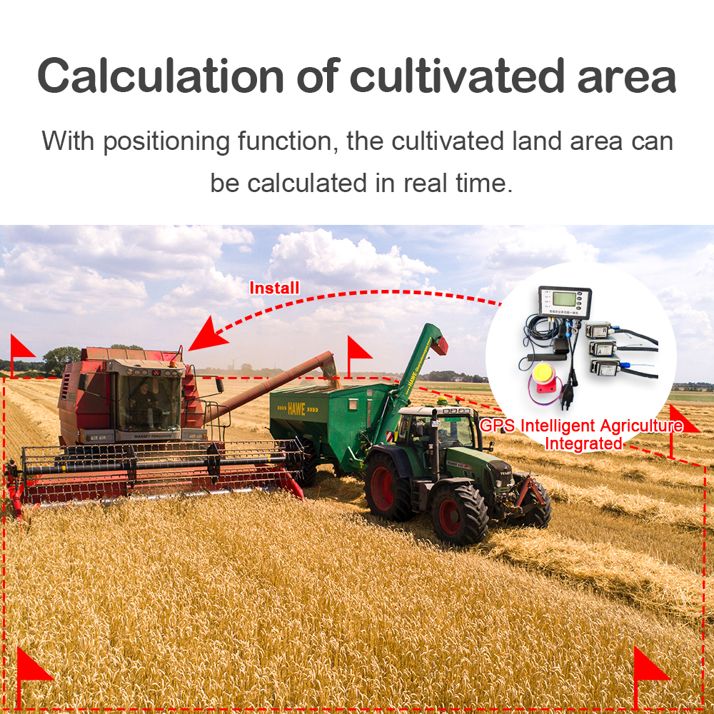
3. Global Positioning System GPS. Since the advent of GPS technology, it has attracted people’s general attention with its advantages of high accuracy, high speed, and simple operation, and has begun to be used in agricultural management. Agricultural spatial analysis requires GPS to describe the soil moisture, fertility, weeds and pests, crop seedling conditions and yield in real time, and track each element. The real-time 3D positioning and precise timing functions of GPS technology provide practical technical means for agricultural digital analysis.
4. Virtual reality VR technology. VR technology refers to the creation of a virtual reality system that allows participants to have a sense of immersion and complete interaction. It provides an immersive feeling for humans to observe nature, appreciate the landscape, and understand the entity. It can use virtual reality technology to demonstrate the situation of crops affected by pests and diseases, the virtual reality of crop growth, the virtual reality of agricultural natural disasters, and the migration of residual pesticides in the land. Simulation etc.
5. Automated and intelligent agricultural machinery operation technology. In the late 1980s, the monitoring system of agricultural machinery and equipment rapidly tended to be automated and intelligent. It has evolved from unit control to distributed control, and from a stand-alone operation system to an integrated management decision system. Agricultural machinery equipped with computers, GPS, GIS and various testing and measuring instruments, such as harvesters, planters, fertilizer spreaders, sprayers, sprinklers, etc., in addition to general agricultural functions, but also automatic operation And gathering and drawing functions.
Post time: Sep-25-2020